

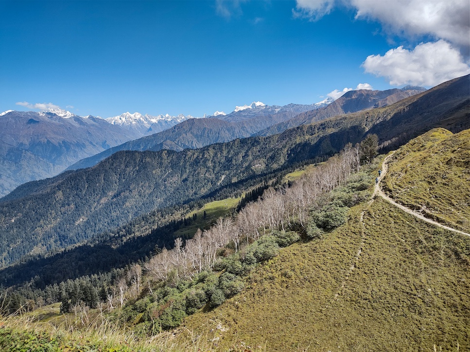
We were talking about homes. After four days of camping in the forests and meadows of the Garhwal Himalayas, I was reluctantly thinking of going back to Delhi, while Labbu Bhai, one of our trekking guides, was looking forward to meeting his six-month-old son further down the hills. We were just a few kilometres from Labbu Bhai’s home descending from the slopes in Uttarakhand, slipping on pine needles and brushing against rhododendrons and oaks around us.
“We commonly use pine trees’ wood to make furniture,” Labbu Bhai tells me, hoping to distract me from the signs of civilization slowly making themselves visible now—an indicator that our trek was ending. When I ask if pine is used to construct buildings, he says, “no, and not many people use wood anyway to build homes anymore. When my grandfather built our home, it initially had three stories, where the ground floor was for our cattle and the upper floors for the rest of the family. The house was mostly made of stone and wood. But, we recently re-built most of it, the majority of it is now made of concrete. It looks modern,” he beams.
Labbu Bhai’s older house was made in the kath kuni style, an architectural design once popular in Himachal Pradesh and Uttarakhand. This regional form of architecture is based on sophisticated interlocking techniques that use wood and stone, and also makes the homes here resilient to earthquakes and heavy rains. But as I reached Sankri village, the endpoint of our trek, I could barely see these designs around me. Instead, cement mixers readied concrete for the many multi-storied buildings and tourist lodges coming up here.
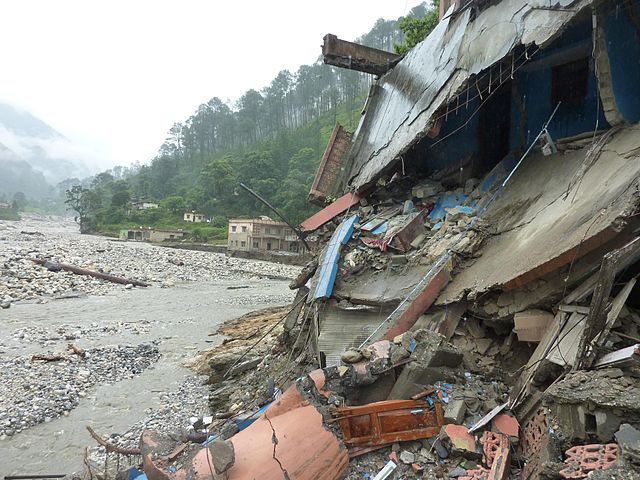
This is bad news. When disasters due to the inevitable seismic activity and cloudbursts of the Himalayas strike, such concrete structures are not resilient to them, as experts have pointed out. In the face of such disasters, these “brittle buildings collapse like cards”.
Uttarakhand is no stranger to the disasters of the Himalayas. In 2021 alone, the state witnessed the tragic Chamoli flash flood in February—just seven months later, it is dealing with ₹7,000 crore worth of damages and a death toll of at least 77 due to heavy rain this October. In fact, 85% of the state’s districts are vulnerable to extreme floods, where associated events like landslides, glacial lake outbursts, and cloudbursts have increased four-fold since 1970. Himachal Pradesh’s situation is not too different; the state’s disaster management cell reports that over 18,500 villages are vulnerable to landslides.
“The Himalayas have often been seen as mountains of risks,” says Dr. Ritodhi Chakraborty, a postdoctoral fellow at Lincoln University who has worked extensively on the political ecology of the Himalayas. “But, over the generations, people have developed the architecture [needed] to live here, because they understood and knew their geography from lived experience. Now, however, the neo-extractive development in this region has changed peoples’ relationships with land [producing] and altered culture, which has disenfranchised the people [historically] dealing with this ecology.”
Hampered access to land and forests, disappearing indigenous knowledge, and changing land relations with the onset of migration to and from the Himalayas have all increased peoples’ vulnerabilities to disasters like flash floods and earthquakes. Without turning the focus to these risks, the conversation on disaster management in the Himalayan region would be incomplete.
The Lands that Diversified Risks
When newly-harvested wheat would be ground into fresh flour, Kamla aunty would do a small pooja. I lived with her family in a rented out room in a village close to Palampur, Himachal Pradesh for a year. “This is to thank the Gods for a good harvest, and for good land,” she told me, as she served me the day’s special—roti made from wheat and kheer.
Even though her husband had a government job, land was important to their family. After all, it provided so much—their private land reaped wheat and some vegetables, common grazing spaces near the stream serviced their two cows, and rhododendron flowers from the forest further up perfect for chutney. The importance of land, and these different uses of it, are replicated across the Himalayan states. Yet, in both Himachal Pradesh and Uttarakhand, access to both land and its assets has been shrinking, increasing communities’ vulnerability to disasters.
“A common pattern in Uttarakhand would be that people practice agriculture, but also collect non-timber forest produce like medicinal plants, or fruits and vegetables from the forests, or have vast pastures for sheep in the bugyals or meadows,” says Chakraborty. “So, if there were heavy rains that damaged crops, people had the common forests to fall back on, that gave them economic security. It was a historical system of distributing their assets.”
This is not to say that pre-colonial India ensured common access to resources for all communities. In Caste and Nature: Dalits and Indian Environmental Politics, Mukul Sharma notes the dangers of romanticising ‘universal’ pre-colonial access to forests, without noting power dynamics that emerge with caste. He critiques ideas of community-based ecological perspectives that fail to highlight the caste layers within non-homogenous communities—layers that decide access to land and water.
But now, forests and common resources which could otherwise protect families from economic shock are being diverted towards various government uses.
A study published this January showed that in Himachal’s Kinnaur district, 984 hectares of forest land had been diverted for development activities between 2012 and 2016, 90% of which had been for hydropower projects. A majority of the trees felled for these projects were cedar and chilgoza pine—the latter is a rare and endangered species, indigenous to the western Himalayan region. While many residents of Kinnaur own apple orchards, chilgoza and its edible nuts fueled a substantial part of the economy where fewer orchards were available. So, as more land was diverted for such projects, the community’s assets also shrunk, making them more vulnerable in the case of a disaster.
On 30th April a massive #landslide occurred on the mountain in which 65 MW Stage 1 of this project is constructed destroying apple orchards & killing a Nepali migrant worker in Pangi village. Video has resident frm village across the river saying “bola tha mat banao zamaane se” pic.twitter.com/IWuc3SsBlK
— Manshi Asher (@ManshiAsher) May 12, 2020
“In the rugged geography of Kinnaur, where only 10 to 11% of the total land available is accessible, there is already contestation over land,” explains Prakash Bhandari, member of Himdhara Research and Action Collective, Palampur, and co-author of the study. “Within this small chunk, communities are living and growing crops, and forest diversions for hydropower projects, and strategic and defence purposes are also taking space,” he adds, highlighting the multiple, but competing uses of land that the district and its people are now dealing with. Bhandari was referring to how the amendments to the Forest Conservation Act, 1980 could further land contestation in the district.
“Land resources are being diverted for plantations or ‘clean’ hydropower projects which allows the government to check the boxes of mitigating climate change. But this garb also allows the State to engage in land grabs [for plantations and other commercial undertakings],” says Chakraborty. “On the other hand, [because of private players] land prices are soaring in Uttarakhand, where in places like Mukteshwar, land is valued at about ₹4 crore per acre. For locals here, this is a good opportunity to sell to non-domiciles who build homes, resorts, and hotels, with the locals themselves migrating out of the areas. In the end, the land in the hands of the locals has shrunk massively, reducing the safety nets they could fall back on in the event of a disaster.”
Migration and Increased Vulnerabilities
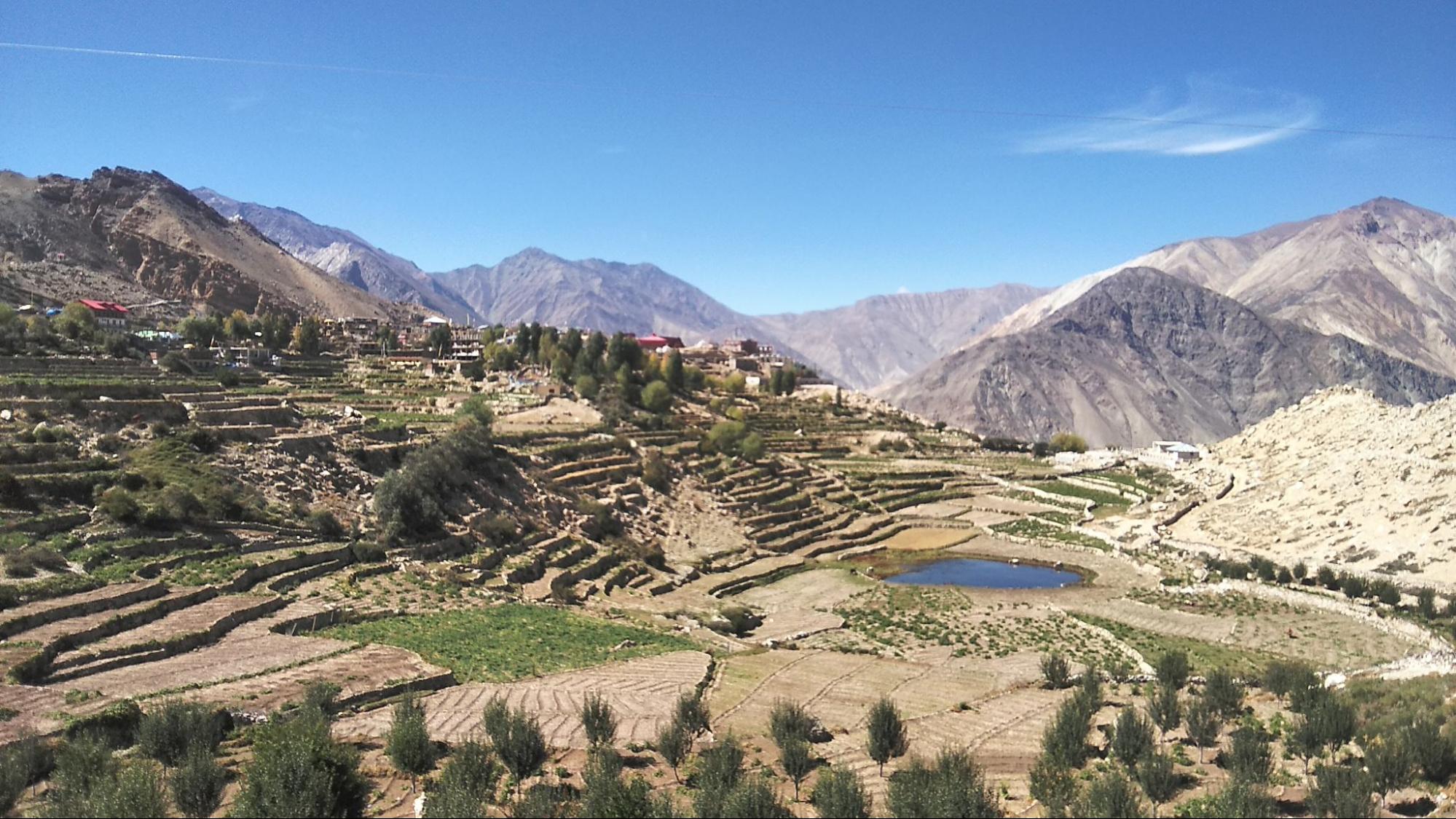
When families migrate, fields are abandoned. In both Uttarakhand and Himachal Pradesh, terrace farming is a common practice, where stone and mud walls are created to protect the steps from falling into the other. These terraces are also linked to each other—so if one farm is abandoned and its wall is damaged, that enhances the risks faced by other farms too in the case of heavy rains or landslides.
Migration to other towns within these states, and the kind of land available to migrants, also shapes their vulnerability to disasters. “Smaller towns [in the two states] are up-and-coming with Smart City Missions, tourism, and rapid urbanisation, which triggers both intra and inter-state migration to these spaces,” says Chitra Rawat, a researcher working on migration in the Himalayas. “But what is not being thought of by town planners and the administration is how this rapid urbanisation will intertwine with disasters.”
Rawat is referring to the cloudburst-induced flash floods in Himachal Pradesh’s Dharamshala in July 2021. “The people who were worst impacted were migrants from other states who had no option but to live on the floodplains after being denied housing countless times. They lost homes and faced so much damage during the flash floods.” One such group were migrants from Maharashtra who had been living on the banks of Dharamashala’s Manjhi river after being evicted from their homes in nearby Chetru for a project under the Smart City Mission. “While land ownership can be a contested issue under the federal structure with different states exhibiting nativist sentiments which go beyond domicile requirements, migrants find themselves disenfranchised from housing as well. There is no real thrust to ensure safe housing options for migrant workers. Where do they go then, in the absence of formal housing? Most likely to places where formal settlements are not allowed, like floodplains, which makes them more vulnerable to floods,” Rawat adds.
These visuals of Cloudburst in Dharamshala, Himachal Pradesh are terrifying.
I urge youth congress workers to help tourists & citizens affected by heavy floods. @IYCHimachal pic.twitter.com/qyHqGQAnFu
— Srinivas BV (@srinivasiyc) July 12, 2021
In Uttarakhand, a flood that still has not escaped public memory is the infamous 2013 ‘Himalayan Tsunami’ of the Kedarnath valley. As waters ravaged life and property, the structure of the Kedarnath temple stood tall and looked barely affected amidst the sea of dilapidated structures surrounding it. The traditional architectural design of the temple was its saving grace.
Leaving Behind a Set of Knowledge
The Kedarnath temple, over 1,200 years old, is made of locally sourced Gneiss stone interlocked with slabs, and a deep foundation of large boulders and stone fillers that reduce the impact of seismic activity. The temple has shown a high degree of resilience during disasters thanks to these architectural innovations. Kath kuni architecture works in a similar way. Wood corners, an essential feature of the style, are interlocked with wood beams which give these structures ductility to survive seismic activity and even landslides—these structures dissipate the force without snapping or breaking apart. But with time, these knowledge systems are disappearing.
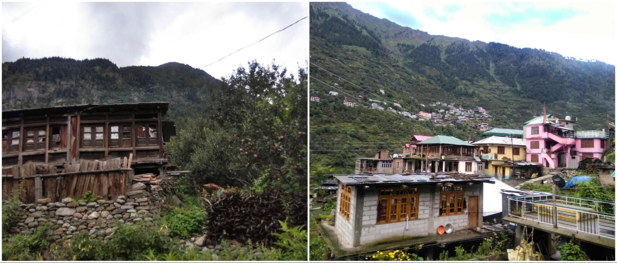
“Knowledge is dynamic, it moves through space and time, almost like a river,” says Chakraborty. “In its face, colonisation was like a dam that stopped the flow of this knowledge.” Findings by Garima Raghuvanshy, a researcher interested in culture and society, concur. She writes that for decades now, kath kuni, which was once economical, has become “prohibitively expensive.” Raghuvanshy estimates that a kath kuni house can cost three times as much as a house made of reinforced concrete.
One of the reasons for increasing costs is the legacy of the colonial forest department—which transformed mixed forests into commercially valuable coniferous monocultures. This made forests of deodar, an important material used in this architectural style, scarce. Post-independence, Raghuvanshy writes, cement construction became the next best material for locals to rely on. Amidst this, this vernacular architecture started diminishing, as did the mistries, or construction experts needed to build kath kuni houses. “Since people stopped popularly using this architecture due to these various reasons, the style did not undergo innovation over the decades,” Raghuvanshy tells me. “Without innovations to suit current day life-style, it can’t be denied that kath kuni does not cater to modern lifestyles—it is outdated, and the rooms can be too small. It’s hardly surprising then that people are moving away from it for practical reasons. When we think of bringing this style back, we need to do that without romanticising the past.”
Even other forms of local knowledge became less popular over time, like those used to choose where to settle. Agriculture has been a mainstay of the economy for communities in Uttarakhand, and was mostly practised along the streams and rivers found in the middle and lower valleys of the Himalayas. But, despite this, people of the region never settled down in the lower reaches of the valley, and preferred habitations over the firm ground at higher elevations that were safe from landslides, floods, and flash floods.
“This was the trend witnessed roughly 100 years ago,” Piyoosh Rautela, Executive Director at Uttarakhand’s Disaster Mitigation and Management Centre, tells me over the phone. “At that time, society at large made these decisions of where to stay, but now, it’s the market that decides access to livelihood opportunities.” In the process, people are settling down at lower elevations as opposed to higher altitudes, “often in close proximity to rivers and streams,” Rautela writes in his blog. This is why, he notes, that most of the losses due to landslides and flash floods in the last decade have been incurred by the newer habitations that recently came up across the state.
“Currently, we are barely recognising our indigenous knowledge [of dealing with disaster resilience] usko use karna toh bahot baad ki baat hai [Using it is a whole different matter]”, Rautela tells me.
My thoughts go back to October 2018 when Himdhara’s Prakash Bhandari, my colleague Aditi, and I were in Spiti for meetings with local communities on the Forest Rights Act. We were invited for dinner to a colleague’s home, a local who headed an NGO there. It had snowed unexpectedly, and we reached his home shivering and covered with at least four layers of clothes on. We entered his traditionally designed mud-walled home, with its flat and low roof, where in the kitchen-cum-sitting space, a wood-fired rocket stove prepared our dinner. In five minutes, we were all in our half-sleeved shirts, while the snow outside continued to fall. For a place like Spiti, which is snowed in for almost six months a year, people’s architectural and indigenous knowledge has kept them warm and prepared throughout. But still, as a few hotels and guesthouses find their way into this trans-Himalayan region, bricks and concrete become the choice of construction for many.
The degree of a disaster’s risk, whether it is floods, earthquakes, or even forest fires depend on how the relations with land and forests in these Himalayan states have altered with the onslaught of an extractive market economy. “While working on mitigating disasters, knowledge should be co-produced with local communities,” says Chakraborty. “This has to go beyond tokenistic measures. The co-production of knowledge must happen at all spheres—be it assessing problems or analysing the progress of mitigation measures and disaster management. As long as communities are not disenfranchised from their land and forests, they will continue possessing this knowledge.”
Featured image: meadows and ridges at Uttarkashi district, Uttarakhand; by Vaishnavi Rathore.


[…] how do these disparate land imaginaries engage with changing climatic realities? These include the increasing frequency of extreme precipitation events, the changing fertilisation […]
[…] find themselves in today, even in remote parts, is one that is embedded in a radically altered “neo-extractive” context of modernity and increasingly powerful governments. These are factors that go beyond the […]